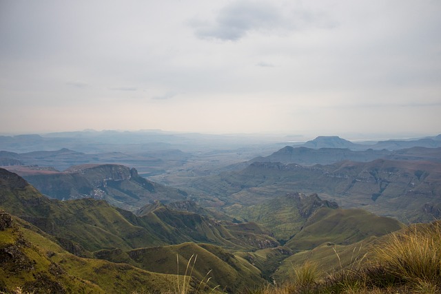
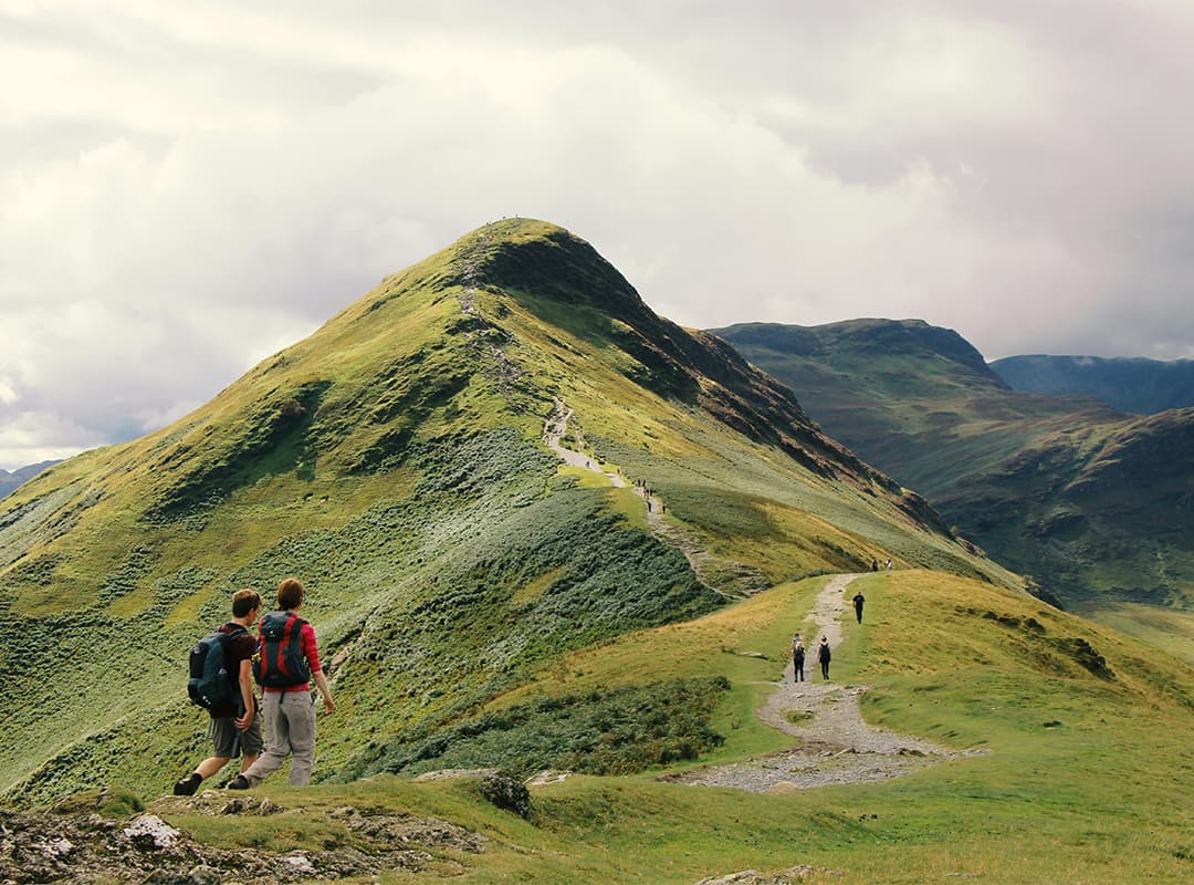
|
| Fires
While fires enhance camp-side
atmosphere they are highly dangerous and are banned from the
wilderness area. (Fires are allowed at official camp sites only.)
The ecology of the Drakensberg is extremely sensitive to fire and an
untimely fire could spell out extinction for some species |
Most resorts, hotels and camps in the Drakensberg
can recommend a wide variety of routes, from a short easy amble through
indigenous fern forests to admire a nearby attraction, to more strenuous
one-day hikes that trail over river and hillside - or head for the more
imposing high ground. There is nothing to beat walking or hiking in the
high country. You will breathe clean, crisp mountain air as you revel in
the sights and sounds of nature. I have compiled a comprehensive
list of the available Drakensberg hiking trails
below. Try one and you can have sensational memories of finishing an
outing with an exhilarating dip in a clear crystal pool hidden in the
sandstone bedrock.
For first time visitors to the Drakensberg see my list
on Drakensberg trails for
tourists with limited time.
Walking and hiking in the Drakensberg is safe and
secure - provided that a few simple ground rules are observed:
In winter, the higher reaches become spectacular
snow-scapes, with the valley and peaks transformed into a wonderland of
white. But if you are adventuring at this time of year, you need to be
aware that glorious sunny days can quickly turn into misty, snowy
conditions. So it is essential that you sign the hiking register at the
beginning of the trail, before heading out.
In summer the Drakensberg is idyllic with bird-song,
luxuriant grasses and wildflowers, and cool streams cascading through
gorges and rock pools. But if you are setting out on a walk on even the
most benign summer afternoon, be alert for sudden thunderstorms that seem
to come from nowhere followed by short spells of unseasonal cold. So in
addition to a camera, carry a jersey or rain jacket, preferably with a
torch and some chocolate in the pockets
The
most popular starting location in the Drakensberg is Monks
Cowl. However Giants
Castle offers just even more beautiful scenery without being so touristy.
The Southern
Drakensberg is without a doubt best experienced at Kamberg
where added to the stunning trails spectacular Bushman Paintings can be
viewed.
If you are interested in more information about the
Drakensberg
or accommodation in the Drakensberg then contact us and we will be
glad to assist.
Day hiking trails in the Northern Drakensberg:
Hiking trails in Royal Natal National Park
Amphitheatre
to Cathedral
Peak
4 to 5 days (62kms)
The route passes parts of the Drakensberg including the Amphitheatre,
Mbundini, Mnweni and The Rockeries, The Saddle and The Cathedral
range.
- Devil's Hoek Valley
A fairly easy hike of 1hr(3km)
The path gets progressively steeper and the views more spectacular.
Royal
Natal National Park. The route takes you from the Tugela River Carpark
along the the Tugela Valley and then up the Devil's Hoek tributary
- Mckinley's Pool, Gudu Falls, The Grotto
Moderate distances, the route is well marked and fairly easy to hike
and explore. There are many clear rock pools where you could enjoy a
swim. Royal Natal National Park, numerous trails leading off from the
Mahai Campsite
up the river valley to Mckinley's Pool.
- Mont-Aux-Sources via Basutho Gate and The
Chain Ladder
10hrs (20kms)
The hike starts from the Mahai River Campsite, follows the Mahai River
Valley, passes the Witsieshoek Mountain Resort, to the Sentinel
carpark and up the Chain Ladder to the escarpment.
-
| Caves
The rock paintings in the caves
in the Drakensberg are all we have left to remind us of the rich
heritage of the Bushmen who once lived here. The paintings are acknowledged
to be the most skilled examples of this type of paining in the
world. These paintings are part of our national heritage and
hikers are not permitted to camp in a cave with paintings. |
Otto's Walk & Bushman Paintings
An easy walk of 1hr (2kms)
The path leads up the Sigubudu Valley to some fine examples San rock
paintings. Royal Natal National Park, begin at the visitor's centre
and takes you along the Tugela
River and continues towards the park gate.
- Rugged
Glen to Mahai
5-6hrs (14kms)
Rugged Glen is a nature reserve connected by road to the Mahai
Campsite.
- Sigubudu Ridge and Valley
A moderate hike of 4-5 hrs (12km)
The path takes you through Protea Veld, past Sunday Falls to Fairy
Glen. Royal Natal National Park. This is a round trip from Mahai
Campsite via Sigubudu Valley.
- Tugela
Gorge
A moderate hike of + 2 hrs (7km)
The route goes through alternative stretches of protea veld and
forest, and the scenery beyond the gorge is rivaled only by the view
from the top of the Tugela Falls.
- Vemaan Valley
A fairly easy hike of 1hr. 45mins (4.3km)
A rare species of protea, known as protea nubigena has been found
here. Royal Natal National Park. Follow the same route as for Devil's
Hoek Valley, but 1 km after turning right at the junction leading up
to Devil's Hoek, the Vemaan Path leads off to the left over the
Devil's Hoek River.
| Compasses
Some hikers swear by, while others
scorn the use of a compass. Many people still blunder their way
through the bush without a clue of how a compass works. And that
fine so long as the paths are kept to. If you go off the paths then
a compass and a 1:50 000 map are very useful tools and learning to
use them is fun |
Hiking trails at Mnweni
- Icidi Pass
An extreme round trip of a minimum of 3 days. The hike starts at
the Isanlwana Police Post in the Mweni Valley and follows the Icidi
River to the escarpment. It requires serious, potentially dangerous
rock scrambling, and should only be attempted by experienced, competent
mountaineers. In the Icidi Valley which is in upper Tugela area of the
KwaZulu-Natal Northern
Drakensberg area.
- Ifidi Pass
Ifidi Valley, Mnweni.
An extreme round trip of a minimum of 3 days. From the Isandlwana
Police Post follow the Mnweni River to its junction with the Ifidi
River. The route then follows the Ifidi River and up Ifidi Pass. This
hike should be led only by competent mountaineers with able parties,
as it requires rock climbing. It is a potentially dangerous route.
- Mbundini and Fangs Passes
An extreme hike of 2 days (27 kms)
Two steep passes in the Mnweni area leading to the top of the
escarpment and enclosing Mbundini Abbey Peak. These passes are steep
and dangerous and should not be attempted by the inexperienced.
- Mnweni via Rockeries and Mnweni Passes
An extreme hike of 4 days (48 kms)
An extremely long and difficult hike which begins at the Isandlwana
Police Post in the Mnweni area. The first day would take you to the
base of the Rockeries Pass, the second to the top and Mponjwane or
Ledgers Cave, the third down the base of Mnweni Pass and the fourth
back to the police post.
- nTonyelana Pass
An extreme round trip of a minimum of 2 days. A long route to the
top of the escarpment from the Isandlwana Police Post, following the
Ntonjelana River.
Hiking trails at Cathedral Peak
- Blue Pool and Nyosi Grotto
A easy 2 hrs or 5.5 kms hike
A short hike in the Cathedral Peak area, starting from the hotel and
following the Nyosi River southwards.
- Cathedral Peak Hike
An extreme 6 to 7 hrs hike - 10km.
A long arduous hike requiring a high level of fitness. Starts from
Cathedral Peak Hotel, up the path to the Cathedral Ridge. Rock
scrambling is often necessary due to rock slides on the gully below
the peak.
-
| Clothing
There are 2 basic considerations
to bear in mind on what clothing to take along.
- the number of changes of clothing required
- the size of your pack
I take a change of two of underwear
and a couple of T-shirts, a winter fleece and a jersey, 1 pair
of shorts and 1 pair of jeans, a good lightweight raincoat. This
way I am prepared for all types of weather.
Socks are something not to be
skimped on. Carry 3 pairs of light cotton socks and 3 pairs of
heavy hiking socks. On long routes I wash my underwear on route
and dry them on the top of my pack.
Finally never ever forget a hat. |
Contour Path - Cathedral Peak to Ndedema
A moderate to severe hike of 3 hours or 3.5 kms
A long hard hike. Starts at Cathedral Peak Hotel, up to contour path
below Cathedral range and follow it southwards. Hike passes underneath
the main escarpment and back down the Ndedema Gorge.
- Contour Path- Ndedema to Monk's Cowl
A moderate 2 day hike(27.5 kms)
A severe hike which starts at the contour path at the upper end of the
Ndedema Valley. This is reached via the solar cliffs path in the
Cathedral area, or via the Hikes' Pass route up to the contour path.
The hike follows the contour path southwards traversing the Mdedela
Wilderness area.
- Ganabu Ridge and Baboon Rock
A severe 6 hr hike(15kms)
The hike starts on the Cathedral Peak route and then branches off to
the right, going down into the Nxwaye valley, up the Ganabu Ridge and
down Baboon Rock.
- Mlambonja Pass to Twins Cave
A severe 6-8 hrs hike (11 kms)
From Cathedral Peak Hotel the path follows the river past the trout
hatchery and up to the top of the little berg above the mlambonja
river. The pass is consistently very steep and long.
- Mlambonja Valley (3)
A moderate 30 mins - 2 hrs hike (1,5 - 5,2 kms)
There are three hikes, the lower valley 1,5 km, neptunes pool 4,2 km
and marble baths 5,2 km. The Mlambonja Pass Route bypasses most of the
lower river valley. All hikes begin at the Cathedral Peak Hotel.
- Mushroom Rock
A fair 1 hr hike (2 kms)
This is a fairly steep hike, which leads up behind the hotel to a
large mushroom-shaped rock.
- Old Furrow Trail
There are displays along the route which makes the trail is convenient
for school groups. The trail gives views of the Bushman's River and
wild animals especially buck may be seen in the open grassland. Picnic
sites are available.
- Oqalweni Forest Walk
An easy 2 hrs hike (5.5 kms)
This route is ideal for hikers who prefer secluded outings. It starts
from the Cathedral Peak Hotel, past the trout hatchery and along the
Oqalweni River to a waterfall and pool.
- Oqalweni Valley
A moderate 5 hrs hike (16.5 kms)
This hike gives you a grand tour of the valley. The path passes
through a number of habitats. It starts at the Cathedral Peak path
past Shermans Cave, but takes the left fork of the contour path around
the top of the Oqalweni Valley and back down one tree hill.
-
| Equipment
Stoves
Essential for cooking and making tea for which ones body seems
to crave in the mountains. Gas cartridge cookers are convenient
and popular but are less efficient than benzene and paraffin
stoves.
Tents
Beware of the cheap versions. Often the material and stitching
is inferior, does not last long and you will find yourself
feeling wet and cold and silly.
Containers
Put everything in plastic household containers. Especially the
matches.
Don't forget a torch, Swiss army
knife and a map. |
Rainbow Gorge
A fair 2 hrs hike (5.5 kms)
This is probably one of the most picturesque hikes in the area. From
the hotel skirt the base of Tryme Hill westwards, then eastwards on
the path into the gorge. Once in the gorge itself the path follows the
river.
- Tarn and Tryme Hills
A hike of4 hrs (10 kms)
This half-day outing affords grand views of the escarpment and close
up encounters with some high spires and butresses, as well as the
possibility of exploring the forests around the available falls, all
on the same stream, a tributory of the Mhlonhlo River.
Cathedral Peak, Central Drakensberg.
- Tseketseke Camp Site
A moderate -severe 4 hrs hike (9.5 kms)
This hike takes one into the mountains directly below Cleft Peak which
dominates the area betweeen Cathedral Peak and Champagne Castle.
- Two Passes and Cleft Peak Escarpment Hike
An extreme 3 days hike (40 kms)
The route starts at the top of Mike's Pass near Cathedral Peak Hotel,
up the long ridge and the very steep Organ Pipes Pass. Traverse the
escarpment and descend via Mlambonja Pass. This hike is classified
extreme and for good reason. Not to be undertaken by the unfit or
inexperienced. Mike's Pass to Cathedral Peak Hotel via Organ Pipes.
| Hints to help you enjoy your
hiking
The secret to enjoyable hiking is to
take it easy and slow. You have to find your own pace and forget
about walking in step with others. In fact you should not consider
walking with people who won't accommodate your pace. In the rush to
get to the top of the mountain don't forget why you are there. Stop
at your leisure, swim in the streams, make tea, look at the view,
the birds, the clouds and just day dream.
Finally carry as little as you can,
it makes the going so much easier. |
- Champagne Castle Via Gray's Pass
An extreme 19 hrs hike (19 kms)
The trail goes up the Mhlwazini Valley, between Champagne Castle and
Dragon's Back on the right and Monk's Cowl on the left, with views so
dramatic that if the path doesn't take your breath away, the secenery
surely will.
- Contour Path- Monk's Cowl to Injasuti
A moderate 9 hrs hike (21 kms)
This hike is the longest, hardest and least used of three possible
routes between Monk's Cowl and Injasuti Camp. The most commonly used
path is the Van Heynigen's Pass & Shada Ridge.
- Crystal Falls and Sphinx
A fair 1 hr 20 mins hike (3 kms)
The path leads south then west across to the Sphinx and further to Breakfast
Stream. This hike is the beginning section of all hikes radiating from
the Monk's Cowl KZN
Wildlife office.
- Fern Forest
An easy 30 minutes (1 kms)
This is a short walk along a forested stream to a waterfall and a
picnic spot.
- Mhlwazini Valley Trail
A severe 9 hrs hike (24 kms)
From the Monks Cowl Camp Site the route ascends the sphinx, and
contours around the top of the Hlatikulu Forest. From there is heads
down into the Mhlwazini Valley and along the river.
- Stable Cave Trail
A moderate 4 hrs hike (9.5 kms)
The route ascends the Steilberg to the top of the little berg. The
cave looks north from a narrow ridge of the Little Berg Plateau
towards the Valley of Pools.
- Sterkspruit Falls and Gorge
A moderate - severe 6 hrs hike (15 kms)
This is a pleasant outing involving some boulder hopping and river
crossings. Start at Monks Cowl Campsite following the Serkspruit River
into the gorge. The return route is further south, running eastwards
across the little berg, down to the Sphinx and Loops down to the
campsite. Long and severe.
| Blisters
The surest way to ruin any hike and
invite disaster is to get blisters. They are easily prevented by
wearing 2 pairs of socks. If your boots are new rub dry soap on the heal
of your outer socks. At the first sign of a blister STOP and put on
a large plaster over the area. Little plasters don't work. |
- Bannerman Hut
A severe 4.5 hrs hike (11 kms)
A long hike from the Giant's Camp northwest along a clear path, with
an early start it is easy to make the hut by mid-morning. The hut must
be booked through KZN Nature Conservation Service.
- Battle Cave to Injasuti Cave
A moderate 4 hrs hike (8.5 kms)
This is a guided tour of the battle cave where a pictorial display of
bushman life In this valley complete with a taped guide to the
paintings are seen. One can stay for a night at the Lower Injasuti
Cave, but bookings must be made in advance for both this and the
battle cave tour. Trout fishing, hiki, swimming, curios, charcoal,
maps.
- Berg view
A fair 2 hrs hike (5 kms)
A short hike from the Giant's
Castle Camp to a popular view point, offering one of the best views
of the escarpment, ranging from Giant's Castle to Cathkin Peak.
- Centenary Hut
A severe 5 hrs hike (10 km)
Injasuti. Follow the path Pastfergy's Cave for 4kms to centenary of
the contourpath
- Champagne Pools
An easy hike (4kms - 1.5 hrs)
A circular walk starting 1km from Giant's Castle main gate. Secluded
pools for swimming and fishing.
- Giant's Castle Pass
An extreme 4 hrs or 6 kms hike (from Giants Hut)
The hike begins at Giant's Castle Camp and continues up to the top of
the little Berg, up the very steep Giant's Pass. Not for the
inexperienced.
- Giant's Hut via Oribi Ridge
A severe 4 hrs hike (10.5 kms)
An alternative route to Giant's Hut just south of the two dassies
stream route. It starts at the main Giant's Castle Camp, climbing
steadily to the hut, which must be booked.
- Grindstone Caves and Cataract Valley
A moderate 4 hrs hike (13 kms)
This hike begins at injasuti camp and follows a circular route via
Grindstone Caves, the waterfalls and Cataract Valley. The path follows
the Mhlwazini River back to the camp.
- Grysbok Bush
A fair 2 hrs 30 mins hike (4 kms)
This hike, starting at Giant's Castle main camp, takes you up the
Bushman's River to the largest forest in the Giant's Castle area .
- Langalibalele Pass
A severe 3 hrs 30 mins hike (6.5 kms)
Follow the path from the main Giant's Castle Camp past the main caves.
The path is consistently steep although the pass itself is one of the
easiest and shortest in the berg.
Follow the path from the main Giant's Castle camp past the main caves.
- Main Caves
An easy 40 mins hike
This hike leads from the camp, along the river near the edge of a
forest, up to the large caves, which are crucial archaeological sites
and have been turned into a museum showing the Bushman's way of life.
Tours are conducted throughout the year at set times in the company of
a field ranger.
- Marble Baths
A moderate hike. (8.5kms - 6hrs)
From Injisuthi Camp follow the route to Fergy's Cave but take the
right fork along the Injisuthi River approximately 4kms from the
start. You can overnight at the Marble Baths Cave.
- Meander Hut
A fair hike. (5.5kms - 2hrs)
There are two ways to get to this hut, which overlooks the Meander
Stream from its perch on top of the cliffs of the Little Berg. The hut
accommodates four people and it must be booked.
- Old Kraal and Yellowwood Forest
An easy 1 hr hike (2.5 kms)
This is a short walk in the vicinity of the camp. From the office at
Injasuti take the Cowl Stream fork. At the top of the incline turn
left to the walls of the old kraal. And shortly after that left again
to the old woman stream. After crossing the river turn left and follow
the path back to camp.
-
| Footware
For long hikes in the Drakensberg
you will need hiking boots. Keep the following in mind and you
should cover many kilometers free from the agony of blisters.
The best hiking boots are made of
light-weight nylon and gortex with rubber soles. They give
support but are light and comfortable.
All boots take time to wear in so
don't buy them the day before you leave
Slipper or sandals are great to
wear at the camp site and don't take up much space in a pack.
Waterproof gaiters keep boots dry
and socks free of burrs and grass seeds. |
River Walk
An easy 1.5kms - 30mins hike
this pleasant stroll has no specific destination and can join the
forest walk for a most enjoyable ramble.
- Spare Rib Cave
A severe 2 hrs hike (3kms)
Injasuti. Proceed up Bannerman Pass from Bannerman Hut. The cave is
near the top of the escarpment on the left hand side.
- Van Heyningen's Pass to View Point
A moderate 3 hrs hike (8 kms)
This will serve as a hikers' orientation with the surrounding
landscapes and major peaks.
- Wildebeest Plateau
A moderate 6 hrs hike (18 kms)
This hike is perfect for a day's outing with opportunties to relax and
swim, and to observe the surroundings at leisure.
- World's view
A moderate 3 hrs hike (7 kms)
From the picnic area take the concrete path down to and across
Bannerman Bridge. Follow the path to below Sugarloaf Kop and on up to
World's View.
Day hiking trails in the Southern Drakensberg:
| Packs and Bags
There are many makes and shapes of
packs and your pocket will most likely dictate your choice. My
advice is don't get a pack that is too big. You just end up taking
more than you really want to carry.
A sleeping bag is vital and it must
be warm enough for below freezing conditions. Down bags are most common
for mountaineering with prices varying with the amount of super fine
down used. Down totally looses its insulating capacity when wet. New
synthetic fiber bags overcome this problem to some extent but are
heavier and bulkier.
I use a down bag, a thin inner sheet
for hygiene and a good quality foam mat to insulate the cold from
the ground. |
- Ash Cave Trail
A 4 hours hike (7.5 kms)
A hike in the Loteni area leading to ash cave in a sandstone band.
Follow the right hand fork in the path along the Loteni River. Cave
must be booked - sleeps 6.
- Cypress Cave
A hike of 2 hours (4.5 kms)
This is one of the few short hikes in the area a small party can use
the cave, which has running water nearby and sleeps six to eight
people, depending on the weather.
- Eagle Trail
A hike of 6 hrs
The trail starts from the rest camp in the Loteni Nature Reserve. It
is a circular route, taking some 6 hours. No facilities are provided
on the trail therfore a lunch pack should be taken and warm clothing
is recommended.
- Gelib Tree Trail
A hike of 2,5 hrs
A short trail offering magnificent views. A descriptive leaflet is
available from the camp manager.
- Hlathimbe Pass and Cave
A hike of 6 - 7 hrs (16 kms)
The hike begins at Loteni
Camp, follows the Ngodwini River path and ascends up to the contour
path. It continues up the very steep Hlathimbe Pass and towards Redi
then southwards several kms to the cave. Not for the inexperienced.
The cave is situated very near to the top of the pass. Sleeps 4.
- Jacobs Ladder
A hike of 2km
Follows the Lotheni River and leads to the spectacular Jacobs Ladder
Waterfall.
- Kamberg
Nature Reserve Trails (2)
A hike of 8 kms
Two trails with rest spots located along the route. The Mooi River
trail has loops each of which is planned to include the physically
disabled. The Gladstone's Nose Trail is considered to be one of the
most beautiful trails in the Drakensberg. Different species of
antelope occur in the area . The trail passes through grassland and
indigenous forests.
- Mhlangeni Pass and Cave
A hike of 3 days (30 kms)
Southern Drakensberg. The hike follows the Mkhomazi and Nhlangeni
Rivers.
- Yellowwood Cave Tarn and Waterfall
A hike of 2 days (23 kms)
From the Loteni Camp follow the Loteni River then left along the
Masinhlonga Fork. The cave is south-facing and very cold in winter.
The route continues up to the contour path, then eastwards back
towards the camp.
| Mountain hygiene
In Colorado's Grand Canyon, river
rafters have to carry their own faeces to prevent degradation of the
river ecology. You don't have to go to these lengths in the
Drakensberg but there are rules you should follow.
Keep away form using rivers, paths,
camp sites and steep slopes for your toilet
Never use soap, shampoo or washing
detergent in streams or pools. Carry water from the river and do the
washing there. Special detergents that are highly bio-degradable
are less harmful to our environment
Carry all your litter back home with
you
Never forget the most important code
of the wilderness is to leave as little trace as possible that you
were there. |
- Bushman's Cave and Ngwangwane Pass
An extreme 6 hrs hike (11 kms)
A severe hike from the Bushman's Nek Police Post along the Bushman's
River westwards. The pass is long and steep. Mzimkulu wilderness area
in the KwaZulu-Natal Southern
Drakensberg.
- Emerald Stream Hike
A fair 3 hrs hike (8.5 kms)
This hike takes one through fertile country with a magnificant view of
Giants Cup.
- Giant's
Cup Trail
A moderate 2 - 5 days hike (68 kms)
The hike begins about 5kms beyond Sani
Pass Hotel and follows a route below the escarpment southwards to
Bushmans Nek,
with most of the route at an average height of 1850m. Transport arrangements
must be made for the end of the hike. This trail is ideal for the less
experienced hiker as it is clearly marked and doesn't ever get that
deep into the mountains. It provides great views, and is a very enjoyable
trail. The serious hiking can be done in the mornings, and with your
backpack in the hut, each hut has options for interesting afternoon
side trips.
Bookings essential.
Gxalingenwa River Trail
13 kms about 4 hours. The hike is good for bird watching and game
viewing. It follows the Emerald Stream, past indigenous forest to a
spectacular waterfall with pools suitable for swimming. It begins on
the Sani Pass Road and has good views of Giants Cup. It leads to
Gxalingenwa Cave.
- Hidden Valley
A moderate 9kms - 3hrs hike
This hike begins at the Garden Castle main office, via Swimn Hut and
along Hidden Valley, returning the same route.
- Hodgson's Peaks
A severe 2 - 3 days hike (19 kms)
The hike starts at Cobham Camp and follows the main Polela River
towards the escarpment, the path becomes less clear and the Masubasuba
Pass is long and difficult.
-
| Food
The principle here is light
but tasty. Essentials like coffee, tea, milk powder, rice and
chocolate should not be forgotten. Hearty and tasty meals can be
made in the mountains by using dehydrated vegetables, meat and
rice and by adding strong flavorings like cayenne pepper and
herbs. Garlic also goes a long way to improving any meal. Onions,
peppers and mushrooms are tasty.
For breakfast muesli and powdered
milk satisfy most hikers
Salami and cheese are good for
lunch and can be supplemented with fruit.
Learn to make bread with self
raising flour. This is easy and your status as a mountain
gourmet will soar. See our page on becoming
a "hiking gourmet"
Chocolate and whiskey are
essential emergency rations so don't skimp |
Lake District
A moderate 8 hrs - 2 days hike
There are many caves in the in the area. A network of parts connects
the caves and places of interest and allows hikers to amble aroud the
section of the Little Berg. Hikes begin from the Cobham Camp. Cobham
State Forest area, which is situated close to Himeville.
- Lammergeyer Cave
A sever 6 - 8 hrs hike (16.5 kms)
From the Buskmans Nek Police Post follow the jeep track westwards
until the path crosses the Ngwangwane River, and heads up a ridge.
Maps and knowledge of the area necessary and cave must be booked.
Sleeps 12.
- Monk and Sleeping Beauty Cave
A moderate 2 hrs hike (4 kms)
This is a shorter walk in this area, and rivers, mountain scenery and
caves can be enjoyed. It starts at the Rengus Station and follows the
Mashai River to sleeping beauty cave and engagement cave a little
further on.
- Pholela River Walk
A fair 3.5 hrs hike (9 kms)
A variety of walks start from the Cobham Hutted Camp and follow the
Polela River, Emerald Stream and Trout Beck. Trout fishing is possible
- with a licence.
- Sani Pass
A severe 7 hrs hike (14 kms)
The hike up the pass begins in the car park 5.5 km past the Sani Pass
Hotel. It is long and steep. Passports are necessary at the top.
- Thomathu Cave and Pass
A severe 4-5 hrs hike (10 kms)
This hike follows a well-defined path on the northern flank of the
Thomathu Ridge. The cave faces north-east and sleeps a large party.
The cave is not very deep though and strong winds can be a problem.
- Three Pools
A fair 2 hrs hike (4.5 kms)
This short walk has two variations; both lead to pools and the extra
distance is more than worth the small effort. It starts at the rangers
station and heads eastwards
The
Drakensberg Mountains present three very different perspectives to its
hikers. And I recommend you see each of these aspects. I have selected
the following as recommended trails because of their ease, spectacular
scenery and last but not least they are well off the beaten tourist track.
You probably will not even see a single other visitor while walking. And
the place to stay while do all this is the Antbear
Guest House which is also my favorite B&B in South Africa
1. Day trail through the lower reaches of the
Drakensberg (Northern / Central 'Berg)
Walking the lower reaches below the Drakensberg escarpment is the
reason you came to this area. This is the most impressive the Drakensberg
has to offer and I recommend Giants Castle Nature Reserve. Try
"Worlds View" an easy 3,5 hour hike (14 km) and ends with a
spectacular 360 degree view. More of this walking beneath the
escarpment can be found at Injasuti, Monks Cowl, Champagne, Cathedral and
Royal Natal. Its similar but the scenery is different and all spectacular.
2. To the top of the Escarpment and the 950m
Tugela Waterfall
There is only one place you can reasonably get to the top of the
Drakensberg escarpment and back down again in one day and that is at the
Sentinel. The drive alone is spectacular. The walk is 5 hours 2,5 hours
each way. You ascend the last 20 meters using a chain ladder and are
rewarded with a view overlooking the Royal Natal Reserve. Also you are at
the source of the Tugela river where it falls some 950m. 2nd highest in
the world.
3. San (Bushman) rock art in the Southern
Drakensberg
Kamberg offers the most spectacular examples of rock art to be found
in South Africa. There are many places where Bushman rock art can be found
but this is one of the few sites where your imagination is not a
prerequisite. Kamberg is situated in the southern Drakensberg (More
sandstone and valleys than the spectacular basalt of further North) which
gives you another opportunity to experience a different aspect of our
Drakensberg.
Drakensberg day walks and walking trails
|
|